Wednesday, 27 January 2016

Beautiful Victoria Memorial Hall


                          Beautiful Victoria Memorial Hall

The Victoria Memorial was built to commemorate the peak of the British Empire in India. The Victoria Memorial, conceived by Lord Curzon, represents the architectural climax of Kolkata city. Lord Curzon, the then Viceroy specified its classical style but the actual plan of Victoria Memorial was laid down by the well-known architect, Sir William Emerson. The Victoria Memorial blends the best of the British and Mughal architecture. The Victoria Memorial hall was built with white Makrana marbles. The Prince of Wales laid the foundation stone of Victoria Memorial in 1906 and it was inaugurated in 1921 in memory of Queen Victoria. The Victoria Memorial is 338 by 228 feet and a height of 184 feet.


Today the Victoria Memorial Hall is a museum having an assortment of Victoria memorabilia, British Raj paintings and other displays. As night descends on Calcutta, the Victoria Memorial Hall is illuminated, giving it a fairy tale look. It is interesting to note that the Victoria Memorial was built without British government funds. The money required for the construction of the stately building, surrounded by beautiful gardens over 64 acres and costing more than 10 million was contributed by British Indian states and individuals who wanted favors with the British government. At the top of the Victoria Memorial is a sixteen foot tall bronze statue of victory, mounted on ball bearings. It rotates with wind.


At present the Victoria Memorial has notable collection of weapons, sculptors, paintings, maps, coins, stamps, artifacts, textiles etc. The Royal gallery in Victoria Memorial has portraits of the Queen and Prince Albert. There are numerous paintings, illustrating events from Victoria's life. Another remarkable peace in Victoria Memorial is a painting by the Russian artist Vasseli Verestchagin, portraying the state entry of the Prince of Wales in Jaipur in the year 1876. In the post independence period a new addition was made to the Victoria Memorial. It was the addition of the National leaders' gallery with the portraits and relics of the freedom fighters.
Share:

Beautiful Varanasi Ghat


                                  Beautiful Varanasi Ghat

Varanasi or Kashi is older than traditions. Varanasi presents a unique combination of physical, metaphysical and supernatural elements. According to the Hindu mythology, Varanasi liberates soul from human body to the ultimate. It is the Ganga Ghats of Varanasi that complement the concept of divinity. Ghats of Ganga are perhaps the holiest spots of Varanasi. The Ganga Ghats at Varanasi are full of pilgrims who flock to the place to take a dip in the holy Ganges, which is believed to absolve one from all sins. There are number of temples on the bank of the Ganga river in Varanasi. It is believed that people are cleansed physically, mentally and spiritually at Ganga Ghats. It is at the Ganga Ghats where we see life and death together. For thousands of years people have been thronging these Ghats to offer their morning prayers to the rising sun. There are more than 100 ghats along side Ganga in Varanasi. Some of the prominent and popular Ghats at Varanasi are the Dasaswamedh Ghat, Manikarnika Ghat, Harischandra Ghat, Kabir Ghat and Assi Ghat.

A boat trip along the river provides the perfect introduction, although for most of the year the water level is low enough for you to walk freely along the whole length of the ghats. It’s a world-class ‘people-watching’ stroll as you mingle with the fascinating mixture of people who come to the Ganges not only for a ritual bath but also to wash clothes, do yoga, offer blessings, sell flowers, get a massage, play cricket, wash their buffaloes, improve their karma by giving to beggars or simply hang around. Assi Ghat , the furthest south of the main ghats, and one of the biggest, is particularly important as the River Assi meets the Ganges near here and pilgrims come to worship a Shiva lingam (phallic image of Shiva) beneath a peepul tree. Evenings are particularly lively, as the ghat’s vast concreted area fills up with hawkers and entertainers. It’s a popular starting point for boat trips and there are some excellent hotels here. Nearby Tulsi Ghat , named after a 16th-century Hindu poet, has fallen down towards the river but in the month of Kartika (October/November) a festival devoted to Krishna is celebrated here. Next along, Bachraj Ghat has three Jain temples. A small Shiva temple and a 19th-century mansion built by Nepali royalty sit back from Shivala Ghat , built by the local maharaja of Benares. The Dandi Ghat is used by ascetics known as Dandi Panths, and nearby is the Hanuman Ghat , popular with Rama devotees (Hanuman was Rama's monkey servant).
Harishchandra Ghat is a cremation ghat – smaller and secondary in importance to Manikarnika, but one of the oldest ghats in Varanasi.


Above it, Kedar Ghat has a shrine popular with Bengalis and South Indians. Continuing north from Scindhia Ghat, you soon reach Ram Ghat , which was built by a maharaja of Jaipur. Just beyond it Panchganga Ghat , as its name indicates, is where five rivers are supposed to meet. Dominating the ghat is Aurangzeb’s smaller mosque, also known as the Alamgir Mosque , which he built on the site of a large Vishnu temple. Gai Ghat has a figure of a cow made of stone. Trilochan Ghat has two turrets emerging from the river, and the water between them is especially holy.Spiritually enlightening and fantastically photogenic, Varanasi is at its brilliant best by the ghats, the long stretch of steps leading down to the water on the western bank of the Ganges. Most are used for bathing but there are also several ‘burning ghats’ where bodies are cremated in public. The main one is Manikarnika: you’ll often see funeral processions threading their way through the backstreets to this ghat.

Share:

Beautiful Shore Temple


                     Beautiful Shore Temple

The Shore Temple at Mamallapuram, built during the reign of the Pallava King Rajasimha (c. 700 - 728), is the earliest important structural temple in Southern India. Its three sanctuaries are dedicated to Vishnu and Shiva. Prominent in this photo are the temple walls, topped by large sculptures of Nandi, and its two steep pyramidal towers capped by octagonal domes. As its name suggests, the Shore Temple overlooks the Bay of Bengal (Mamallapuram was the port city of Kanchipuram, the Pallava capital). Its location, so near the sea, has resulted in considerable erosion of the temple's superstructure. Shore Temple comprises three shrines, where the prominent ones are dedicated to Lord Shiva and Lord Vishnu. In the garbhagriha (sanctum sanctorum), an image of Shivalinga embraces the site. At the rear end, one can find two shrines facing each other. Here, one shrine is dedicated to Ksatriyasimnesvara and other to Lord Vishnu. In the shrine, Lord Vishnu is imaged reclining on the 'Seshanag', which is a symbol of consciousness in Hinduism.

The exterior wall of the shrine to Lord Vishnu and the internal side of the boundary wall are elaborately carved and sculptured. The images on the sculpted panels depict scenes from everyday life. However, the sculptures are incredibly real and artistic. The exterior walls of the temple are segregated by plasters into bays, where the lower part has been impressed into a series of nurturing lions. The archeological department has excavated certain other figures from the site. Shore Temple is no more a living temple. The structure of the temple makes one to contemplate and perhaps, it was erected basically as a work of art. The Pallavas were known to be the great patrons of art and were keen to create their own style of temple architecture. In the present day, Shore Temple makes the background of Mahabalipuram Dance Festival that is held in Jan /Feb every year. The festival was organized to promote the traditional dance as well as tourism in Mahabalipuram. Shore Temple is also acknowledged for being the first stone structure made by Pallavas. Before this, the monuments used to be carved out of the rocks or stones. Unlike other monuments of the region, Shore Temple is a five-storied rock-cut structural temple more willingly than monolithical.

In southern India, this is one amongst the earliest and most important structural temples. The spire is extensively decorated with carvings and sculptures. In the recent years, a stone wall has been constructed to protect the shrine from further sea-erosion.  Perched on a 50 feet square plinth, the pyramidal structure raises to the extent of 60 feet. Presenting a typical specimen of Dravidian temple architecture, Shore Temple generates an exclusive combination of history and natural splendor. The temple was designed to grasp the first rays of the rising sun and to spotlight the waters after sunset. In the words of Percy Brown, Shore Temple served as "a landmark by day and a beacon by night".The two towers rise above shrines to Shiva and their original linga (phallic symbols of Shiva) captured the sunrise and sunset. Between the Shiva shrines is one to Vishnu, shown sleeping. Rows of Nandi (Shiva's vehicle) statues frame the temple courtyard.

Share:

Beautiful Loch Ness Monument

  
          Beautiful Loch Ness Monument


A tranquil location that is open all year, offers stunning scenery and panoramic views around Loch Ness to the mountains beyond; with a back drop of woodlands, forestry and the most spectacular flora and fauna Donald, whose family have been on the farm on which the camp site has been built for generations, along with his wife Lyn, have an excellent knowledge of the area and its history. Donald and Lyn are assisted by their managers; Colette and Mark Tolley, who have worked on a Camping and Caravanning Club Site for the last 3 years. This friendly and informative team aim to make your visit to the site as enjoyable as possible. The site offers facilities to 5* standard, including under floor heating in Am Fasgadh; the Reception/Shop and amenity block, which includes home from home shower rooms, alongside all other amenities that would be  expected on a quality touring site, aspiring to meet the new VisitScotland 5* criteria. Donald and his team are determined to run a ‘green’ business, using innovative renewable energy, including wat r-to-water geo-thermal plus solar thermal, with the electricity provided by hydro power. Carbon management is also demonstrated through the choice of buildings, with energy efficient construction and low impact, locally sourced, materials. One of only a few places with easy access to the shore around Loch Ness, this site provides an opportunity to canoe, kayak or launch small boats, fish for trout and salmon or if prefer hire a boat and gillie locally.  The Great Glen Canoe Trail passes the site, which provides Trailblazer rest for canoeist and kayaks to stay overnight, get a hot shower and stock up on provisions. Fire pits and everything else you need for a BBQ on the shore or picnics are available at the site shop.

The most famous picture of Nessiteras Rhombopteryx, to give Nessie its full name, came from London gynecologist Robert Wilson. On April 19, 1934, Wilson reported seeing something on the water and took a snap: a long neck of the monster had just emerged from the ice-cold water. It later turned out that Wilson belonged to a team who had set out to play a trick on the media. Shortly before his death in 1993, Christian Spurling, one of the "conspirators", admitted his part in the great deception. According to the Sunday Times, Spurling, an amateur woodworker, had rigged up a dinosaur dummy on a toy submarine. The ruse worked perfectly.The spectacular flora and fauna, offers something for everyone with regular sighting of wildlife such as red squirrels, badgers, wild goats, otters, bats and deer and over 40 specifies of wild birds likely to visit the site and surrounding area.  Numbers confirmed by a RSPB survey in 2012, (once on site ask for a copy of the species list), approximately half of these birds fall into the rare (species of medium conservation concern) or in danger (species of high conservation) category.


Wildlife hides are available and walks, ranging from a short leisurely stroll to Foyers Pier, to a wide range of forestry paths in the vicinity, offer numerous options for everyone. There is also an opportunity to take part in a range of organised activities including walks, bird watching, geo-caching, plus archery and mini-bus tours of the wider area.


Share:

Amazing Admiralty Island

                Amazing Admiralty Island


Admiralty, second largest island in the massive Alexander Archipelago, dominates the northern half of the Panhandle. The island is more or less half way between Juneau and Sitka. It is 96 miles long, northeast to south, and about 30 miles in width at its widest. It embraces 678 miles of coastline, highly irregular with many bays and estuaries, and a total area of over a million acres or 1,664 square miles. Dense green spruce and hemlock forests cover much of the island although only about 20 percent of the area is attractive to timber harvesting. Only a few logging scars show, and many old harvest areas are heavily overgrown with second growth. There are broad valley systems that have never been harvested and are, except for occasional windthrows, literally unbroken carpets of green, pristine wilderness. The area is wet (100-inches-plus annually except for "dry" spots like Angoon, in the rain-shadowed lee of snowcapped Baranof Island to the southwest) climax forest in which underbrush and down trees frequently make foot travel difficult.

A spine of mountains runs up the northern portion of the island, where the treeline ends at around 2,000 to 2,500 feet, with dark forests giving way to alpine meadows and twisted little pines and dwarf spruces in a parkland of flowers, lush grasses, ground plants like the dwarf dogwood or bunchberry, heart leaves and other growth on which Sitka blacktail deer grow fat throughout the summer. To the north, this spine tapers needle-like to Point Retreat, a favorite fishing spot.

South of the spine, in the center of Admiralty, a strong geologic contract breaks the continuity of the mountain complex and a vast mid-island lowlands area embraces a myriad of lakes and streams across the island from west to east. the island reaches its greatest. The Greens Creek mine is an underground silver, gold, zinc and lead mine located on the northwest end of the island, within the national monument. It began operations in 1989.

Admiralty Island also offers opportunities for outdoor recreation in Southeast Alaska. The U.S. Forest Service maintains several public-use cabins on the island, as well as the Cross Admiralty Canoe Route, which links the island's lakes through a series of portages. The Pack Creek Brown Bear Viewing Area offers visitors the opportunity to observe brown bears in their natural habitat as they fish for salmon and interact with one another during the summer months. Permits are required for all visitors to Pack Creek; they can be obtained through the Forest Service.


While bears outnumber people, bald eagles outnumber bears and provide one of the more outstanding features of Admiralty Island--an estimated 2,500 reside on Admiralty Island--more than all bald eagles known to exist in the remainder of the United States. A graphic plotting of nests in the area identified by U.S. Fish and Wildlife Service biologists results in the intricate outlining of the entire island's coastline. Angoon, Admiralty Island's only permanent community, lies at the entrance to Mitchell Bay on Chatham Strait. Its people are mostly Tlingit Indians, descendants of the tribes that have controlled the Straits for centuries. Access to Angoon is limited to float planes and the Alaska Marine Highway ferry. This physical isolation from other population centers, coupled with the land in which they live, has served to set Angoon apart from other towns in southeast Alaska in terms of culture and lifestyle. Angoon has been called the stronghold of Tlingit culture.


Share:

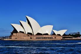
Sydney Opera House

 Sydney Opera House 


Hiii Everyone,
                    Here some information about Sydney Opera House.


Beautiful against the backdrop of Sydney Harbour, the iconic Sydney Opera House is a thriving hub of art, culture and history. It's one of the world's most distinctive buildings, attracting millions of visitors from all over the world. Experience all that the Sydney Opera House has to offer by taking a guided tour, watching a show, and enjoying a cocktail beside the harbour at the Opera Bar as the sun sets over this stunning triumph of architecture and design.From 1957 to 1963, the design team went through at least 12 iterations of the form of the shells trying to find an economically acceptable form (including schemes with parabolas, circular ribs and ellipsoids) before a workable solution was completed. The design work on the shells involved one of the earliest uses of computers in structural analysis, to understand the complex forces to which the shells would be subjected. The computer system was also used in the assembly of the arches. The pins in the arches were surveyed at the end of each day, and the information was entered into the computer so the next arch could be properly placed the following day. In mid-1961, the design team found a solution to the problem: the shells all being created as sections from a sphere. This solution allows arches of varying length to be cast in a common mould, and a number of arch segments of common length to be placed adjacent to one another, to form a spherical section. With whom exactly this solution originated has been the subject of some controversy. It was originally credited to Utzon. Ove Arup's letter to Ashworth, a member of the Sydney Opera House Executive Committee, states: "Utzon came up with an idea of making all the shells of


uniform curvature throughout in both directions. Alternatively, The Backstage Tour is a must for anyone who wants to discover secrets about what really goes on behind the scenes at the Sydney Opera House. Lasting for 2 hours, this tour will let you peek behind the curtain to discover the dramas and the mysteries of Australia's most celebrated theatre. If you happen to be in Sydney around early June you may catch the Vivid Sydney festival. The festival transforms Sydney with fantastic arrays of light, music and ideas.Of course, one of the best ways to experience the Sydney Opera House is to see a show. Don't be fooled by the name the Opera House Sydney's premier venue is not just for operas, but for ballets, plays, pop music, symphonies, comedy, contemporary dance, musical theatre and much more. Finally, no trip to the Sydney Opera House would be complete without a stroll around the Royal Botanic Gardens. Take a picnic basket, lie down in the grass and make the most of Sydney's gorgeous harbour views and sunny weather.The major hall, which was originally to be a multipurpose opera/concert hall, became solely a concert hall, called the Concert Hall. The minor hall, originally for stage productions only, incorporated opera and ballet functions and was called the Opera Theatre, later renamed the Joan Sutherland Theatre. As a result, the Joan Sutherland Theatre is inadequate to stage large-scale opera and ballet. A theatre, a cinema and a library were also added. These were later changed to two live drama theatres and a smaller theatre "in the round". These now comprise the Drama Theatre, the Playhouse and the Studio respectively. These changes were primarily because of inadequacies in the original competition brief, which did not make it adequately clear how the Opera House was to be used.


Diners can enjoy the stylish Bennelong, a sumptuous yet relaxed dining venue set within the famous sails of the Sydney Opera House. Under the helm of award winning Chef Peter Gilmore, Bennelong offers both a high-end dining experience as well as a middle section designed for diners who are after a casual bite and beverage. Bennelong also welcomes those looking for an apertif before the show. You can also enjoy lunch and dinner at one of the world-class restaurants around Circular Quay, while taking in the view of the Sydney Opera House and the Harbour Bridge.


Share:

The Colosseum in Rome

The Colosseum in Rome

Hi Everyone,
                     Here Something about historical monument.Colosseum and Borghese Private Tour Pre Booking Tickets. Skip the line.Located just east of the Roman Forum, the massive stone amphitheater known as the Colosseum was commissioned around A.D. 70-72 by Emperor Vespasian .Jump to  Colosseum. Sestertius of Titus celebrating the inauguration of the Colosseum .


The Colosseum is without any doubt the first place that has to be visited in Rome, as well as one of the main attractions in the city. Built in 80AD, this almost two thousand years old monument was the largest amphitheater of ancient Rome. Today is one of the symbols of Rome and Italy in the world. Inside the Colosseum were held gladiator fights, bloody battles between men and wild beasts, and duels between slaves; but recent discoveries show that it was possible to flood the arena, in order to stage authentic naval battles: a clear sign that the Colosseum was at the forefront of architecture and technology. Today, the Colosseum is one of the most visited archaeological sites in Italy and throughout the world. Visiting this outstanding monument is a unique opportunity to go back in time: a must-see for all tourists who visit Rome for the first time, but also for those who think they already know the city.


You can visit the Colosseum through guided tours for groups and small groups, or, for a truly intimate and unforgettable eXPerience, also through a private tour that will make you your trip to Rome unforgettable. These guided tours also give you access to the archaeological area of the Roman Forum, which will give you a glimpse of the opulence of ancient Rome.Even after the decadent Roman emperor Nero took his own life in A.D. 68, his misrule and excesses fueled a series of civil wars. No fewer than four emperors took the throne in the tumultuous year after Nero’s death; the fourth, Vespasian, would end up ruling for 10 years (A.D. 69-79). The Flavian emperors, as Vespasian and his sons Titus and Domitian  were known, attempted to tone down the excesses of the Roman court, restore Senate authority and promote public welfare. Around 70-72, Vespasian returned to the Roman people the lush land near the center of the city, where Nero had built an enormous palace for himself after a great fire ripped through Rome in A.D. 64. On the site of that Golden Palace, he decreed, would be built a new amphitheater where the public could enjoy gladiatorial combats and other forms of entertainment.


Hundred day games were held by Titus, Vespasian's successor, to mark the inauguration of the building in 80 AD. In the process, some nine thousand wild animals were slaughtered.The highly ostentatious opening ceremony, lasted one hundred days during which people saw great fights, shows and hunts involving the killing of thousands of animals (5000 according to the historian Suetonius). For the opening, the arena space was filled with water for one of the most fantastic events held in Roman times, naumachias – real sea battles reproducing great battles of the past.


Share:

Tuesday, 26 January 2016

Beautiful Big Ben

 Beautiful Big Ben

Hi everyone,
                  Here some exclusive information about  Big Ben in London.Big Ben is the nickname for the Great Bell of the clock at the north end of the Palace of Westminster in London, and often extended to refer to the clock.The Houses of Parliament's iconic clock tower is one of London's most famous landmarks. ... The Houses of Parliament and Elizabeth Tower, commonly called Big Ben, are among London's most iconic landmarks.The Clock Tower of the Palace of Westminster - officially named Saint Stephen's Tower - is commonly known as the Big Ben.


The Houses of Parliament and Elizabeth Tower, commonly called Big Ben, are among London's most iconic landmarks. Technically, Big Ben is the name given to the massive bell inside the clock tower, which weighs more than 13 tons (13,760 kg).  The clock tower looks spectacular at night when the four clock faces are illuminated.There were two bells cast as the clock tower's hour bell. A first, sixteen ton weighing bell was cast by John Warner and Sons in 1856. Since the Clock Tower was not yet completed, the bell was hung temporarily in the Palace Yard. The bell soon cracked so it was recast in 1858 in the Whitechapel Bell Foundry as a 13.5 ton bell. Unfortunately soon after this bell was placed in the belfry in July 1859, it cracked as well.

This time, instead of yet again recasting the bell, the crack was repaired and a lighter hammer was used to prevent any more cracks. The hour bell was probably named after Benjamin Hall, the First Commissioner of Works. Some sources however claim the bell was named after Benjamin Caunt, a British heavyweight boxing champion. The clock was the largest in the world and is still the largest in Great-Britain. The clock faces have a diameter of almost 25ft (7.5m). The hour hand is 9ft or 2.7m long and the minute hand measures 14ft (4.25m) long.  The clock is known for its reliability, it has rarely failed during its long life span. Even after the nearby House of Commons was destroyed by bombing during World War II, the clock kept on chiming. The clock's mechanism, designed by Edmund Beckett Denison, has a remarkable accuracy. The clock's rate is adjusted by simply adding small pennies on the shoulder of the pendulum.Unfortunately the clock tower is not publicly accessible, but if you're looking for views over London the London Eye, the Shard or the Monument are currently the best options.


The tower was constructed between 1843 and 1858 as the clock tower of the Palace of Westminster. The palace is now better known as the Houses of Parliament.  The clock tower rises 316ft high (96m) and consists of a 200ft (61m) high brick shaft topped by a cast iron framed spire. The clock faces are 180ft / 55m above ground level.
Share:

Historical Place Machu Picchu

Historical Place Machu Picchu


Hi Everyone,
                    Here some exclusive information about Machu Picchu .


Machu Picchu stands 2,430 m above sea-level, in the middle of a tropical mountain forest, in an extraordinarily beautiful setting. It was probably the most amazing urban creation of the Inca Empire at its height; its giant walls, terraces and ramps seem as if they have been cut naturally in the continuous rock escarpments. The natural setting, on the eastern slopes of the Andes, encompasses the upper Amazon basin with its rich diversity of flora and fauna. The complex of palaces and plazas, temples and homes may have been built as a ceremonial site, a military stronghold, or a retreat for ruling elites—its dramatic location is certainly well suited for any of those purposes. The ruins lie on a high ridge, surrounded on three sides by the windy, turbulent Urubamba River some 2,000 feet (610 meters) below.

Scholars are still striving to uncover clues to the mysteries hidden here high in the eastern slopes of the Andes, covered with tropical forests of the upper Amazon Basin. Machu Picchu appears to lie at the center of a network of related sites and trails—and many landmarks both man-made and mountainous appear to align with astronomical events like the solstice sunset. The Inca had no written language, so they left no record of why they built the site or how they used it before it was abandoned in the early 16th century.
Landscape engineering skills are in strong evidence at Machu Picchu. The site’s buildings, walls, terraces, and ramps reclaim the steep mountainous terrain and make the city blend naturally into the rock escarpments on which it is situated. The 700-plus terraces preserved soil, promoted agriculture, and served as part of an extensive water-distribution system that conserved water and limited erosion on the steep slopes.


The Inca’s achievements and skills are all the more impressive in light of the knowledge they lacked. When Machu Picchu was built some 500 years ago the Inca had no iron, no steel, and no wheels. Their tremendous effort apparently benefited relatively few people—some experts maintain that fewer than a thousand individuals lived here.Embedded within a dramatic landscape at the meeting point between the Peruvian Andes and the Amazon Basin, the Historic Sanctuary of Machu Picchu is among the greatest artistic, architectural and land use achievements anywhere and the most significant tangible legacy of the Inca civilization. 


Recognized for outstanding cultural and natural values, the mixed World Heritage property covers 32,592 hectares of mountain slopes, peaks and valleys surrounding its heart, the spectacular archaeological monument of “La Ciudadela” (the Citadel) at more than 2,400 meters above sea level. Built in the fifteenth century Machu Picchu was abandoned when the Inca Empire was conquered by the Spaniards in the sixteenth century. It was not until 1911 that the archaeological complex was made known to the outside world.


Share:

Monday, 25 January 2016

The Great Wall Of China

  The Great Wall Of China
Hi Everyone,

                   Here somthing about our historical place great wall of China.The Great Wall of China is a series of fortifications made of stone, brick, tamped earth, wood, and other materials, generally built along an east-to-west line .The Great Wall of China is one of the greatest sights in the world — the longest wall in the world, an awe-inspiring feat of ancient defensive architecture.


The Great Wall is a China icon. It shows us not only China's culture of national pride, grand projects, and determined resistance, but also China's extravagant architecture and creativity. During the construction of the Great Wall, there were many interesting legends and myths, such as Meng Jiang Nü weeping over the Great Wall, a sad but romantic love story set in the Qin Dynasty. Read more on Great Wall Culture — Legends, Stories, Poetry.The Great Wall, one of the greatest wonders of the world, was listed as a World Heritage by UNESCO in 1987. Just like a gigantic dragon, it winds up and down across deserts, grasslands, mountains and plateaus, stretching approximately 13,170 miles (21,196 kilometers) from east to west of China.


 With a history of more than 2,000 years, some of the sections are now in ruins or have disappeared. However, it is still one of the most appealing attractions all around the world owing to its architectural grandeur and historical significance.The Great Wall stretches across North China from east to west for over 6,000 kilometers. It extends from the shanhai pass at the seaside in the Hebei province in the east to the Jiayu pass in Gansu province in the west. The sites of the Great Wall stretch across 15 provinces of China.


But since the great wall in Beijing is very long and protected well while most of the great walls in other China areas are not kept well and opened for tourists, it is commonly thought Beijing is the only place to see the Great Wall. "Greatest Human Feat in History": The Great Wall is the building project with the longest duration and greatest cost in human lives, blood, sweat and tears. It deserves its place among "the New Seven Wonders of the World" and the UNESCO World Heritage Sites.
Share:

The Christ the Redeemer

 The  Christ the Redeemer


Hii Everyone,
                   Here somthing about Historical Monument.Christ the Redeemer (Portuguese: Cristo Redentor, standard Brazilian Portuguese.This statue of Jesus stands some 38 meters tall, atop the Corcovado mountain overlooking Rio de Janeiro. Designed by Brazilian Heitor da Silva Costa.
Christ the Redeemer is a statue in Rio de Janeiro, Brazil that was built as a symbol of Brazilian Christianity. In 1850, the idea of building a religious monument .


Christ the Redeemer, Portuguese Cristo Redentor,  colossal statue of Jesus Christ at the summit of Mount Corcovado, Rio de Janeiro, southeastern Brazil. It was completed in 1931 and stands 98 feet (30 metres) tall, its horizontally outstretched arms spanning 92 feet (28 metres). The statue, made of reinforced concrete clad in a mosaic of thousands of triangular soapstone tiles, sits on a square stone pedestal base about 26 feet (8 metres) high, which itself is situated on a deck atop the mountain’s summit. The statue is the largest Art Deco-style sculpture in the world and is one of Rio de Janeiro’s most recognizable landmarks. This statue of Jesus stands some 38 meters tall, atop the Corcovado mountain overlooking Rio de Janeiro.
 Designed by Brazilian Heitor da Silva Costa and created by French sculptor Paul Landowski, it is one of the world’s best-known monuments. The statue took five years to construct and was inaugurated on October 12, 1931. It has become a symbol of the city and of the warmth of the Brazilian people, who receive visitors with open arms.After its completion, the statue was dedicated on October 12, 1931. Over the years it has undergone periodic repairs and renovations, including a thorough cleaning in 1980, in preparation for the visit of Pope John Paul II to Brazil that year, and a major project in 2010, when the surface was repaired and refurbished. Escalators and panoramic elevators were added beginning in 2002; previously, in order to reach the statue itself, tourists climbed more than 200 steps as the last stage of the trip. In 2006, to mark the statue’s 75th anniversary, a chapel at its base was consecrated to Our Lady of Aparecida, the patron saint of Brazil.


Permission was granted, and the foundation stone of the base was ceremonially laid on April 4, 1922—to commemorate the centennial on that day of Brazil’s independence from Portugal—although the monument’s final design had not yet been chosen. That same year a competition was held to find a designer, and the Brazilian engineer Heitor da Silva Costa was chosen on the basis of his sketches of a figure of Christ holding a cross in his right hand and the world in his left. In collaboration with Brazilian artist Carlos Oswald, Silva Costa later amended the plan; Oswald has been credited with the idea for the figure’s standing pose with arms spread wide. The French sculptor Paul Landowski, who collaborated with Silva Costa on the final design, has been credited as the primary designer of the figure’s head and hands. Funds were raised privately, principally by the church. Under Silva Costa’s supervision, construction began in 1926 and continued for five years. During that time materials and workers were transported to the summit via railway.
Share:

The Stonehenge

The Stonehenge 

Hii Everyone,
                    Here somthing about Historical monument of United State.Stonehenge is surely Britain's greatest national icon, symbolizing mystery, power and endurance. Its original purpose is unclear to us, but some have speculated .Walk in the footsteps of your Neolithic ancestors at Stonehenge – one of the wonders of the world and the best-known prehistoric monument in Europe. It is a prehistoric monument located in Wiltshire, England, about 2 miles (3 km) west of Amesbury and 8 miles (13 km) north of Salisbury.


Stonehenge is surely Britain's greatest national icon, symbolizing mystery, power and endurance. Its original purpose is unclear to us, but some have speculated that it was a temple made for the worship of ancient earth deities. It has been called an astronomical observatory for marking significant events on the prehistoric calendar. Others claim that it was a sacred site for the burial of high-ranking citizens from the societies of long ago. While we can't say with any degree of certainty what it was for, we can say that it wasn't constructed for any casual purpose. Only something very important to the ancients would have been worth the effort and investment that it took to construct Stonehenge.

For centuries, historians and archaeologists have puzzled over the many mysteries of Stonehenge, the prehistoric monument that took Neolithic builders an estimated 1,500 years to erect. Located in southern England, it is comprised of roughly 100 massive upright stones placed in a circular layout. Whi1e many modern scholars now agree that Stonehenge was once a burial ground, they have yet to determine what other purposes it served and how a civilization without modern technology—or even the wheel—produced the mighty monument. Its construction is all the more baffling because, while the sandstone slabs of its outer ring hail from local quarries, scientists have traced the bluestones that make up its inner ring all the way to the Preseli Hills in Wales, some 200 miles from where Stonehenge sits on Salisbury Plain. Today, nearly 1 million people visit Stonehenge, a UNESCO World Heritage Site since 1986, every year.


The World Heritage property Stonehenge, Avebury and Associated Sites is internationally important for its complexes of outstanding prehistoric monuments. Stonehenge is the most architecturally sophisticated prehistoric stone circle in the world, while Avebury is the largest. Together with inter-related monuments, and their associated landscapes, they demonstrate Neolithic and Bronze Age ceremonial and mortuary practices resulting from around 2000 years of continuous use and monument building between circa 3700 and 1600 BC. As such they represent a unique embodiment of our collective heritage.


Modern theories speculate that the stones were dragged by roller and sledge from the inland mountains to the headwaters of Milford Haven. There they were loaded onto rafts, barges or boats and sailed along the south coast of Wales, then up the Rivers Avon and Frome to a point near present-day Frome in Somerset. From this point, so the theory goes, the stones were hauled overland, again, to a place near Warminster in Wiltshire, approximately 6 miles away. From there, it's back into the pool for a slow float down the River Wylye to Salisbury, then up the Salisbury Avon to West Amesbury, leaving only a short 2 mile drag from West Amesbury to the Stonehenge site.
Share:

The Taj Mahal

The Taj Mahal


Hi Everyone,
                     Here somthing about india monument,


 The Taj Mahal is the epitome of Mughal art and one of the most famous buildings in the world. Yet there have been few serious studies of it and no full analysis of its architecture and meaning. Ebba Koch, an important scholar,  has been permitted to take measurements of the complex and has been working on the palaces and gardens of Shah Jahan for thirty years and on the Taj Mahal itself—the tomb of the emperor's wife, Mumtaz Mahal—for a decade. At the brink of dawn when the first rays of the sun hits the dome of this epic monument, it radiates like a heavenly abode, cloaked in bright golden.

And then at dusk, basking in the glory of moon, it shines like a perfectly carved diamond; appearing as if straight owwut of some magical tale, leaving the viewers awestruck by its sense of grandeur. Nothing short of an architectural marvel, no wonder it stands proud at being one of the Seven Wonders of the World. And the rich beauty of this visual spectacle turns visceral when one hears the story behind it. The story of Taj Mahal! Taj Mahal, "the epitome of love", is "a monument of immeasurable beauty". The beauty of this magnificent monument is such that it is beyond the scope of words. The thoughts that come into the mind while watching the Taj Mahal of Agra is not just its phenomenal beauty, but the immense love which was the reason behind its construction. Mughal Emperor Shah Jahan got this monument constructed in the memory of his beloved wife Mumtaz Mahal, with whom he fell in love at the first sight. Ironically, the very first sight of the Taj Mahal, the epitome of love and romance, also leaves visitors mesmerized and perpetually enthralled.


The tomb is the representation of the house of the queen in Paradise, and  its setting was based on the palace gardens of the great nobles that lined both sides of the river at Agra India.  You will explore the entire complex of the Taj Mahal with an explanation of each building and an account of the mausoleum's urban setting, its design and construction, its symbolic meaning, and its history up to the present day.


Standing majestically on the banks of River Yamuna, the Taj Mahal is synonymous to love and romance. The name "Taj Mahal" was derived from the name of Shah Jahan's wife, Mumtaz Mahal, and means "Crown Palace". The purity of the white marble, the exquisite ornamentation, precious gemstones used and its picturesque location, all make a visit to the Taj Mahal gain a place amongst the most sought-after tours in the world. However, until you know the love story behind the construction of the Taj Mahal, the beauty of the same would not enliven in your heart and mind and instead would come up as just another beautiful building/monument. It is the love behind this outstanding monument that has given a life to this monument. Come and explore the visceral charisma that it emanate
Share:

Hawa Mahal

Hawa Mahal

Hii Everyone,
                     Hereformation about Hawa Mahal.


The renowned 'Palace Of The Winds', or Hawa Mahal, is one of the prominent tourist attractions in Jaipur city. Located in the heart of Jaipur, this beautiful five-storey palace was constructed in 1799 by Maharaja Sawai Pratap Singh who belonged to Kachhwaha Rajput dynasty. The main architect of this palace built of red and pink sandstone, is Lal Chand Ustad and the palace is believed to have been constructed in the form of the crown of Krishna, the Hindu god. Considered as an embodiment of Rajputana architecture, the main highlight of Hawa Mahal is its pyramid shape and its 953 windows or 'Jharokhas' which are decorated with intricate designs. The main intention behind the construction of the Mahal was to facilitate the royal women and provide them a view of everyday life through the windows, as they never appeared in public. Read further to know more about Hawa Mahal, its history, architecture and its visiting hours.

Jaipur’s most distinctive landmark, the Hawa Mahal is an extraordinary, fairy-tale, pink sandstone, delicately honeycombed hive that rises a dizzying five storeys. It was constructed in 1799 by Maharaja Sawai Pratap Singh to enable ladies of the royal household to watch the life and processions of the city. The top offers stunning views over Jantar Mantar and the City Palace one way, and over Siredeori Bazaar the other.
There’s a small museum (Saturday to Thursday), with miniature paintings and some rich relics, such as ceremonial armour, which help evoke the royal past. Claustrophobics should be aware that the narrow corridors can sometimes get extremely cramped and crowded inside the Hawa Mahal. Entrance is from the back of the complex. To get here, return to the intersection on your left as you face the Hawa Mahal, turn right and then take the first right again through an archway.
  

Architecture
Hawa Mahal, designed as a beehive castle with small windows, has a height of 50 feet from its base. This structure, erected on a thin shield or podium approximately fifty feet high, has walls less than a foot thick. Constructed of red and pink sandstones by Lal Chand Ustad, Hawa Mahal is famous for its windows or 'Jharokhas' which enable free circulation of air within the structure. Its entrance is a door which leads to a spacious courtyard surrounded by two-storey buildings on three sides. 
Of the five storeys of the Mahal, the top three storeys have the thickness of a single room while the bottom storeys have courtyards. The interior of the Hawa Mahal is stark and plain with passages and pillars reaching to the top storey. The building does not have stairs to reach the upper floors; the storeys are connected by slopes. From Hawa Mahal, you have an excellent view of the city. The monument also has an archeological museum.
Share:

Thursday, 21 January 2016

Jama Masjid

                         Jama Masjid 


Mughal emperor Shah Jahan built the Jama Masjid between 1644 and 1656. It was constructed by more than 5000 workers. It was originally called Masjid-i-Jahan-Numa, meaning 'mosque commanding view of the world'. The construction was done under the supervision of Saadullah Khan, wazir during Shah Jahan's rule. The cost of the construction at the time was one million Rupees. Shah Jahan also built the TajMahal, at Agra and the Red Fort in New Delhi, which stands opposite the Jama Masjid. The Jama Masjid was completed in 1656 AD. The mosque was inaugurated by a Imam Bukhari, a mullah from Bukhara, Uzebekistan, on 23 July 1656, on the invitation from Shah Jahan. About 25,000 people can pray in the courtyard at a time and it is sometimes regarded as India's largest mosque. The mosque is commonly called "Jama" which means Friday.

After the British victory in Revolt of 1857, they confiscated the mosque and stationed their soldiers here.They also wanted to destroy the mosque to punish the people of the city. But due to opposition faced, the demolition was not done. In November 2011, the Delhi Police arrested six members of the Indian Mujahideen who were believed to be behind the Jama Masjid blast along with the Pune German bakery blast. Sources said that the "'main man' Imran" allegedly planted the planted the bomb in a car outside the mosque. In September 2013 it was reported that, Yasin Bhatkal, a leader of the group, along with Assadullah Akhtar, were arrested last month and admitted that they carried the attack with on the run Pakistani national Waqas. Yasin said that he was ordered by Karachi-based IM head Riyaz Bhatkal to do the task as the Imam allowed "semi-naked" foreigners inside it. The floor plan of the mosque is similar to that of the Jama Masjid of Agra.


 It is covered with white and black ornamented marble to look like a Muslim prayer mat. Beside it, a thin black border measuring 3 feet long and 1.5 feet  wide is marked for the worshippers. There are 899 total such boxes.  The architecture and plan of Badshahi Masjid which was built by Shah Jahan's son Aurangzeb in Lahore is closely related to that of the mosque.


 Before the Revolt of 1857, there was a madrasa near the southern end of the mosque, which was during the revolt destroyed.
Share:

Angkor Wat, Cambodia.

Angkor Wat, Cambodia. Hello friends, Today I ll tell you about Angkor Wat, Cambodia. When you’re visiting the temples, w...

Powered by Blogger.

About

About Me

I am Aarushi Mishra and I have started this website in January 2015 on Blogger.I started this website to provide latest information regarding monuments in the different parts of the world . beautifulmonumentsworld.blogspot.com is a blog that provide all informations of different monuments around the world .

Read More

Contact Form

Name

Email *

Message *